Bude Aqueduct Maps Permissive Path
[et_pb_section admin_label=”section” transparent_background=”off” background_color=”#afb0bc” allow_player_pause=”off” inner_shadow=”off” parallax=”off” parallax_method=”off” padding_mobile=”off” make_fullwidth=”off” use_custom_width=”off” width_unit=”on” make_equal=”off” use_custom_gutter=”off” gutter_width=”3″][et_pb_row admin_label=”row” make_fullwidth=”off” use_custom_width=”off” width_unit=”on” use_custom_gutter=”off” gutter_width=”3″ padding_mobile=”off” background_color=”#2d3250″ allow_player_pause=”off” parallax=”off” parallax_method=”off” make_equal=”off” parallax_1=”off” parallax_method_1=”off” parallax_2=”off” parallax_method_2=”off” column_padding_mobile=”on” custom_padding=”|25px||25px”][et_pb_column type=”2_3″][et_pb_text admin_label=”Main Text” background_layout=”dark” text_orientation=”left” use_border_color=”off” border_color=”#ffffff” border_style=”solid” custom_padding=”|25px||25px”]
Bude Canal Aqueduct – Permissive Path
This is an enlarged section from the Aqueduct map showing the permissive path in greater detail.
NB The Permissive Path section is currently closed with access ending at the locked gate except for pre organised walks through our contact details, (enquiries@bude-canal-trust.co,uk) although the remainder of the Aqueduct Trail remains open to the public.
Clicking on the image will open another tab where you can right-click to print a copy.
[/et_pb_text][et_pb_image admin_label=”Image” src=”http://www.bude-canal-trust.co.uk/wp-content/uploads/2021/06/Permissive-path.jpg” show_in_lightbox=”off” url=”http://www.bude-canal-trust.co.uk/wp-content/uploads/2017/02/Map-permissive-path-more-detail.jpg” url_new_window=”on” use_overlay=”off” animation=”left” sticky=”off” align=”left” force_fullwidth=”off” always_center_on_mobile=”on” use_border_color=”off” border_color=”#ffffff” border_style=”solid”]
[/et_pb_image][et_pb_text admin_label=”Text” background_layout=”dark” text_orientation=”left” use_border_color=”off” border_color=”#ffffff” border_style=”solid”]
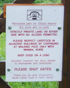
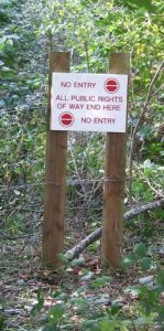
Walkers are reminded that this is a permissive path and no deviation from the 650 metre route can be made. The access gates are clearly marked with the BCT logo and the start and end sections are also quite clearly marked. Photographs of the signs at the start and end of this section are adjacent to this text.
This is the sign at the start of the Permissive Path section, please proceed with care.
This is the sign that marks the end of the Permissive Path section. Please, on no account. proceed beyond this point.
[/et_pb_text][/et_pb_column][et_pb_column type=”1_3″][et_pb_blurb admin_label=”Link with image” title=”Canal Maps” url_new_window=”off” use_icon=”off” icon_color=”#7EBEC5″ use_circle=”off” circle_color=”#7EBEC5″ use_circle_border=”off” circle_border_color=”#7EBEC5″ icon_placement=”top” animation=”off” background_layout=”dark” text_orientation=”left” use_icon_font_size=”off” background_color=”#585969″ use_border_color=”off” border_color=”#ffffff” border_style=”solid” custom_padding=”5px|5px|5px|5px”]
[/et_pb_blurb][/et_pb_column][/et_pb_row][/et_pb_section]


